Introduction
For my tutorial, I’m going to show how to collect and import coordinate data into ArcGIS. This skill has many possible implications for a variety of projects. Projects dealing with data that has geographical/spatial aspects should have a way to visually represent this data since it’s relevant to understanding it. For example, If I was working with a police department and had access to a database with the locations of 911 calls reporting car break-ins. If the goal is to figure out where the most activity is, It would be highly effective to visually represent where break-ins are happening in the city using ArcGIS instead of looking at a large sheet of call records.
I chose this as my tutorial topic because of my midterm, linked here, where I had to implement this skill to visually represent a spreadsheet of comic locations accurately. I feel like this skill is unique enough to meet the requirements for this assignment and I’ve had enough time learning it to effectively teach it to others.
Steps For Importing a Sheet
Before considering finding the coordinates of your items, be aware that ArcGIS allows for importing of Addresses and Places. If your data is already in that format, that is the better option.
1. If you already have your coordinate data proceed to step 2, Otherwise, to find coordinates for your locations I recommend using google maps to find the exact spot you’re looking for. For example, my final project group is making an interactive map of all the clubs at Carleton, and we’re taking data like “Field Behind Hill of Three Oaks” and are using google maps to find the exact locations to extract the coordinates. To get the coordinates of a location: either click on a spot yourself to create a blip on the map or click on a blip that’s already there, typically this happens when you’re finding the coordinates of a building or business. Now you simply right-click the blip on the map and copy those coordinates, as seen below.

2. If you already have your coordinate data in two separate columns in your google sheet, move on to step 3. This project was A LOT of data cleaning. A part of this was making sure the data was being collected in a way ArcGIS would accept. No matter what your project is about, you need to have your data in a coordinate format, with latitude and longitude each getting their own respective columns in your sheet as seen below. If you did step 1 as I described, you have copied coordinate data as one string into only one column of your sheet. This is easily fixable if you’re using google sheets. Simply highlight the column with your data, click the Data tab above the sheet, and select “Split Text to Columns.”

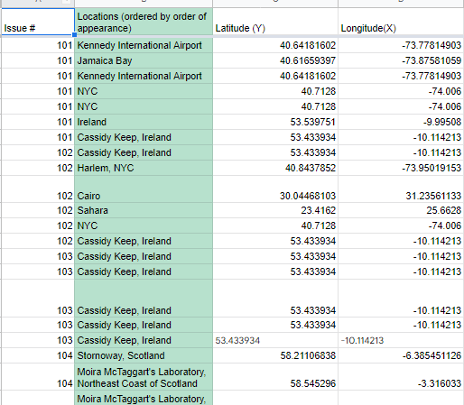
3. Now that you have your data, ensure that you have all the desired metadata you want about each item in the row that corresponds with its coordiantes such as Title/Name, description, etc. Below is a screenshot of what my spreadsheet looked like for my midterm. Each row is one item. I had information like Issue number, Context, and how many times each item appeared. The last column was not necessary though, as ArcGIS does a count for you.

4. The next step is to download your sheet as a CSV file. Click the file tab above, then download, then select the .csv option.

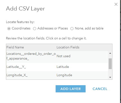
5. Now open ArcGIS and click Add and select Add Layer From File. Select your CSV file and you should be on a screen that lets you assign latitude and longitude to the corresponding rows in your file. Click ADD LAYER when you’ve assigned the latitude and longitude.
6. Finally, choose an attribute to show. The two key options are “location by order of appearance” and “location only.” You have many options for the style of visual representation of the data under the Select a drawing style tab. Note that different attributes chosen to show will allow for either more or less drawing styles to be selectable.

Finished! You’ve turned your data into an interactive ArcGIS map. For more resources on ArcGIS, check out this documentation or if you want a very simplified version of this tutorial, here is a quick one-page tutorial on importing coordinates.